Sonoma County has many many micro climates, not only relating to temperature, but also with precipitation. For example Santa Rosa averages a little over 30 inches of rain a year, but if you travel 10 to 20 miles away, rainfall averages can be much higher. Cazadero, in western Sonoma County one year received 117 inches of rain! Sometimes for several years in a row Cazadero receives well over 50 inches of rain each year. Santa Rosa tends to have … [Read more...]
Santa Rosa, CA – Specialty Farms

Note: Much of Sonoma County typically is not a good place to grow stone fruits or melons – exception to this are the Crane Melons which need certain micro climates. Any fruit or vegetable that requires a lot of heat will typically not do well in most of Sonoma County – especially West county and near Santa Rosa/Petaluma. Leafy green things you can eat – grow best in the mild growing conditions of this country. Some farms, ranches, and orchards … [Read more...]
Santa Rosa, CA – Farmers Markets

Numerous farmer's markets are located throughout Sonoma County. Unlike in the southern part of the state where year round farmer's markets are the norm, seasonal farmers markets far outnumber the year round ones up here. Seasonal smaller markets tends to have live music while the year round (often larger markets) do not always use music to liven up your shopping experiences. We have visited all of the farmers' markets in Santa Rosa and Sonoma … [Read more...]
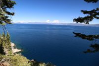
Lake Tahoe, CA
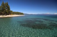
Lake Tahoe, The Lake, is the jewel of the Sierra Nevada's. At 6,226 feet above sea level Lake Tahoe is the largest alpine lake in North America. It is 12 miles wide, and 22 miles long. The Lake has a surface area of 191.6 square miles. The average depth of The Lake is 989 feet, while its deepest point is 1,645 feet. This is the third deepest lake in North America. Lake Tahoe contains about 40 trillion gallons of water. To put that number in … [Read more...]
Lake Tahoe, CA – Mileage
Mileages from Lake Tahoe to: … [Read more...]
Santa Barbara, CA – Mileage
Mileages from Santa Barbara to: … [Read more...]
Santa Barbara, CA – Museums

For the relatively small population of Santa Barbara, the amount of and quality of museums will surprise you. Here are a select few that we have personally visited; they are listed in alphabetical order: Carpinteria Valley Museum of History is located at 956 Maple Ave, just south of Carpinteria Ave. Descendants of Carpinteria's pioneer families donated household furnishings and clothing to this museum. A turn of the century schoolroom and … [Read more...]
Santa Barbara, CA – City & Regional Parks
For hiking enthusiasts there are dozens of foothill trails in the Santa Ynez mountains. Maps and information can be obtained from Los Padres National Forest Headquarters located at 42 Aero Camino, in Goleta. Chaucer's Bookstore on State Street (mentioned in the Other Information section) has a number of good books and maps on day hiking in the Santa Barbara area. The Phone Number of the Los Padres National Forest is (805) 683-6711. Some of … [Read more...]
Santa Barbara, CA – Radio Stations
The following is a list of radio stations in the Santa Barbara area and also stations that you are able to hear in Santa Barbara, but originate out of Los Angeles. We make a concerted effort to keep this page updated as radio stations are constantly changing format or locations on the dial. Email Dave if you have any updates for this page. Select AM stations: Select FM Stations: … [Read more...]
San Luis Obispo, CA

San Luis Obispo, California (Population 45,595) is located nearly midway between Los Angeles and the San Francisco Bay area. With urban sprawl kept to a minimum and almost ideal weather this town is a great place to live! San Luis Obispo is located about 240 miles from San Francisco and about 200 miles to Los Angeles. Driving the scenic route along Highway 1 to San Francisco is about 260 miles. Highway 1 is certainly slower then Highway 101 … [Read more...]